MyTopo
Chatham Virginia US Topo Map
Couldn't load pickup availability
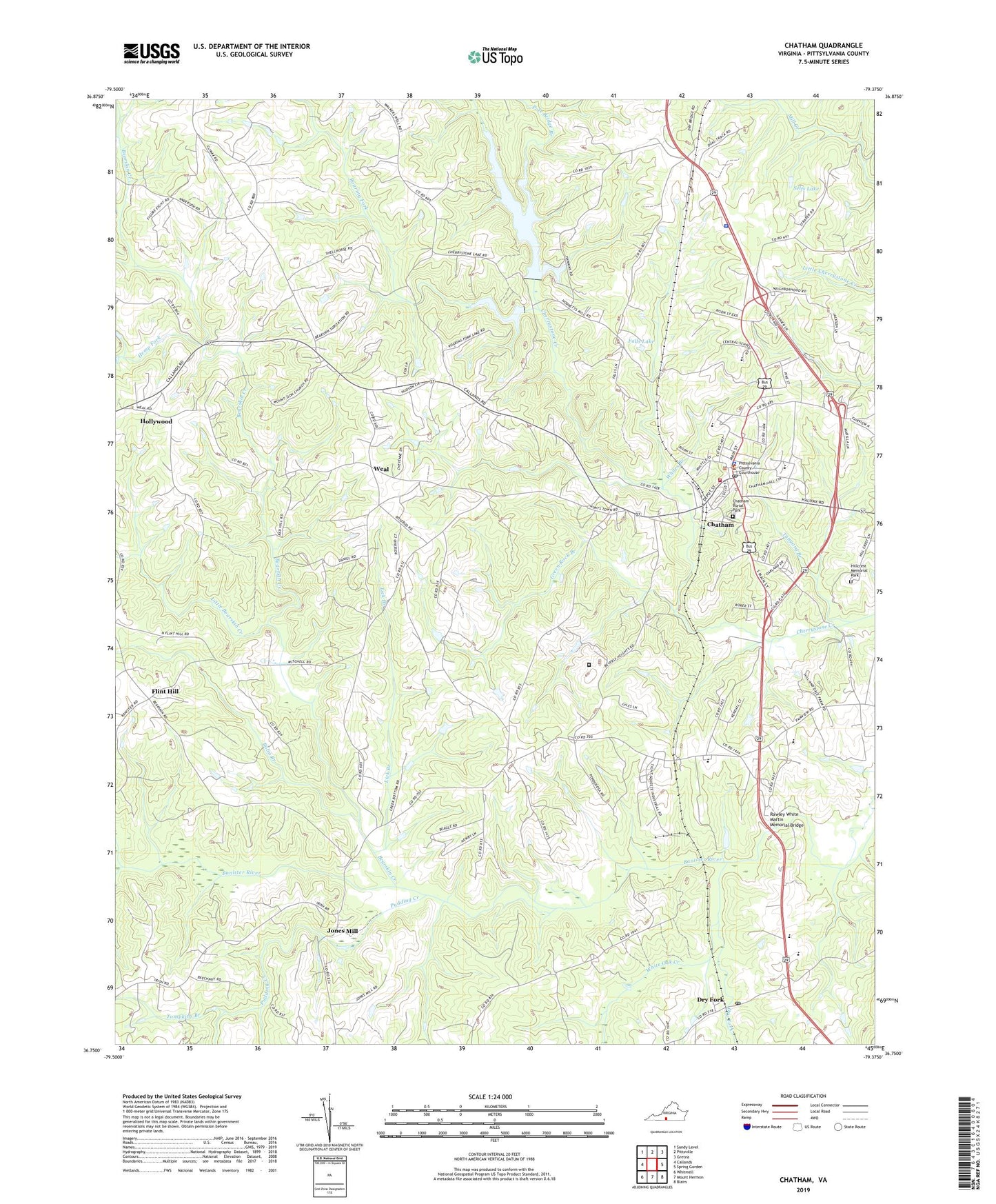
2022 topographic map quadrangle Chatham in the state of Virginia. Scale: 1:24000. Based on the newly updated USGS 7.5' US Topo map series, this map is in the following counties: Pittsylvania. The map contains contour data, water features, and other items you are used to seeing on USGS maps, but also has updated roads and other features. This is the next generation of topographic maps. Printed on high-quality waterproof paper with UV fade-resistant inks.
Quads adjacent to this one:
West: Callands
Northwest: Sandy Level
North: Pittsville
Northeast: Gretna
East: Spring Garden
Southeast: Blairs
South: Mount Hermon
Southwest: Whitmell
This map covers the same area as the classic USGS quad with code o36079g4.
Contains the following named places: Adams Dam, Banister Church, Banister Springs Church, Bearskin Creek, Belle Grove Church, Beverly Chapel, Beverly Heights, Bold Spring Church, Bolin Branch, Central Elementary School, Chatham, Chatham Burial Park, Chatham Christian Church, Chatham Church, Chatham Elementary School, Chatham Hall School, Chatham High School, Chatham Middle School, Chatham Police Department, Chatham Post Office, Chatham Presbyterian Church, Chatham Rescue Squad, Chatham Town Hall, Chatham Volunteer Fire Department, Cherrystone Number 2a Dam, Cherrystone Number One Dam, Clark Church, Concord Church, Concord School, Crews School, Dame Memorial Church, Dry Fork, Dry Fork Post Office, Eldon Knolls, Emmanuel Episcopal Church, Falls Lake, First Baptist Church, Flint Hill, Galilee Church, Giles Dam, Gilmer Terrace, Green Rock Branch, Green Rock Correctional Center, Halifax Hills, Hargrave Military Academy, Hemp Fork, Hillcrest Memorial Park, Hodnets Mill, Hodnets School, Hollywood, Hollywood Baptist Church, Jefferson-Watson Airport, Jones Mill, Kendall Dam, Lick Branch, Little Bearskin Creek, Marion Church, Moses Mill, Mount Zion Church, Oak Grove Church, Oakland, Oakland Church, Pigg School, Piney Level School, Pittsylvania Career and Technical Center, Pittsylvania County, Pittsylvania County Courthouse, Pittsylvania County Health Clinic, Pittsylvania County Jail, Pittsylvania County Poor Farm, Pittsylvania County Public Library, Pittsylvania County Sheriffs Office, Pittsylvania County Sheriff's Office, Pole Bridge Branch, Pruden Hall, Pudding Creek, Rawley White Martin Memorial Bridge, Regional One Emergency Medical Services Base 3, Rehobeth Church, Roaring Fork, Rosebud School, Saint Lukes Church, Saint Pauls Church, Selfs Lake, State Prison Camp Number 15, Strawberry Creek, Tanyard Branch, Tight Squeeze, Tight Squeeze Plaza Shopping Center, Tompkins Branch, Town of Chatham, Triumph Church, Vanderhyde Dairy, Virginia Polytechnic Institute Tobacco Research CentER, Virginia State Police Division 6 Area 43 Office, Watson Memorial United Methodist Church, Weal, White Oak Creek, White Oak Grove Missionary Baptist Church, Whitehead Dam, Whites Branch, Whittletown, Willis Hall, WKBY-AM (Chatham), Woodlawn, Woodlawn Academy, Woodlawn Heights, ZIP Code: 24531