MyTopo
Centralia Washington US Topo Map
Couldn't load pickup availability
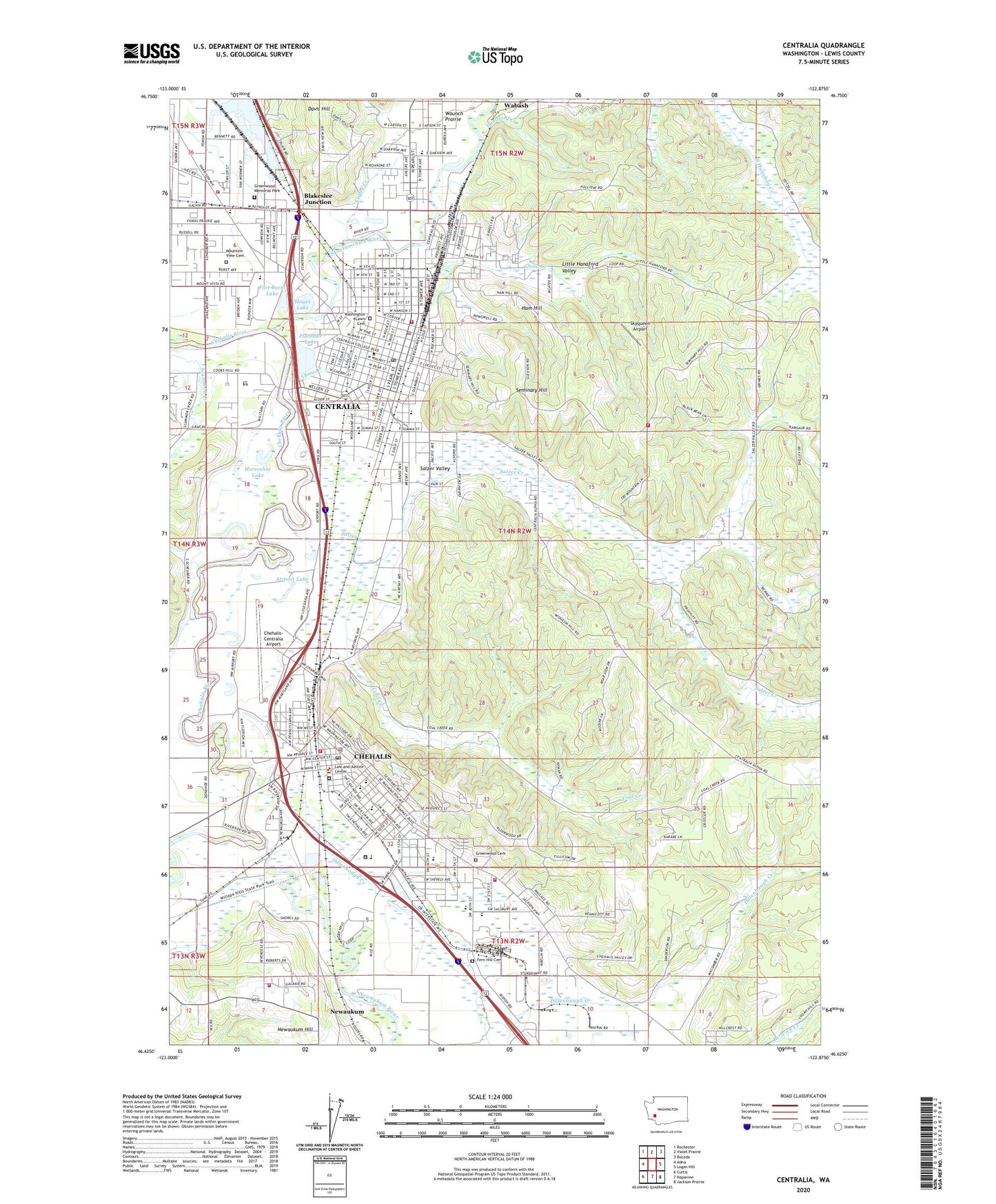
2023 topographic map quadrangle Centralia in the state of Washington. Scale: 1:24000. Based on the newly updated USGS 7.5' US Topo map series, this map is in the following counties: Lewis. The map contains contour data, water features, and other items you are used to seeing on USGS maps, but also has updated roads and other features. This is the next generation of topographic maps. Printed on high-quality waterproof paper with UV fade-resistant inks.
Quads adjacent to this one:
West: Adna
Northwest: Rochester
North: Violet Prairie
Northeast: Bucoda
East: Logan Hill
Southeast: Jackson Prairie
South: Napavine
Southwest: Curtis
This map covers the same area as the classic USGS quad with code o46122f8.
Contains the following named places: Airport Lake, Alexander Park, American Medical Response, Berwick Creek, Blakeslee Junction, Borst Lake Dam, Brick Wagner Park, Cascade Elementary School, Centralia, Centralia Christian School, Centralia College, Centralia College Building 11, Centralia College Building 21, Centralia College Child and Family Studies Building, Centralia College Child Development Center, Centralia College Clock Tower, Centralia College Early Childhood Education Building, Centralia College Facilities Operations and Maintenance Building, Centralia College Hanson Administration Building, Centralia College Health and Wellness Center, Centralia College Health Science Annex, Centralia College Kemp Hall, Centralia College Kirk Library, Centralia College Laboratory Annex, Centralia College Parent Education / Early Childhood Education Building, Centralia College Science Center, Centralia College Security Building, Centralia College Student Center, Centralia College Technology Center, Centralia College Teens Entering Education Now Classrooms, Centralia College Teens Entering Education Now Offices, Centralia College Washington Hall, Centralia College Work First Resource Center, Centralia College Work First Worker Retraining Intake Center, Centralia Elks Golf Course, Centralia Fire Department, Centralia Junior High School, Centralia Police Department, Centralia Post Office, Centralia Rifle Club, Centralia-Chehalis Division, Chehalis, Chehalis Fire Department, Chehalis Junction, Chehalis Middle School, Chehalis Police Department, Chehalis Post Office, Chehalis-Centralia Airport, China Creek, City of Centralia, City of Chehalis, Coal Creek, Coffee Creek, Dillenbaugh Creek, Edison Elementary School, Fairway Shopping Center, Fern Hill Cemetery, Fords Prairie, Fords Prairie Elementary School, Fort Borst Lake, Fort Borst Park, Green Hill School, Greenwood Cemetery, Greenwood Memorial Park, Ham Hill, Hanaford Creek, Hayes Lake, Henderson Park, Horseshoe Lake, Jefferson Lincoln Elementary School, John Dobson Park, KCED-FM (Centralia), KELA-AM (Centralia-Chehalis), KITI-AM (Centralia-Chehalis), Lewis County Fire District 12 Riverside Fire Authority Station 2, Lewis County Fire District 12 Riverside Fire Authority Station 4, Lewis County Fire District 6 Main Station 61, Lewis County Fire District 6 Newuakum Hill Station 64, Lewis County Jail, Lewis County Juvenile Detention Center, Lewis County Juvenile Detention School, Lewis County Sheriff's Office Chehalis, Little Hanaford Valley, Logan Elementary School, McFadden Park, Mountain View Cemetery, Newaukum, Newaukum River, Noble Field, Oakview Elementary School, Olympic Club, Olympic Elementary School, Plummer Lake, Providence Centralia Hospital, R E Bennett Elementary School, Recreation Park, Riverside Golf Course, Riverside Park, Saint Joseph School, Saint Marys School, Salzer Creek, Salzer Valley, Scheuber Drainage Ditch, Seminary Hill, Seminary Hill Natural Area, Skookumchuck River, Skyqueen Airport, Southwest Washington Fairgrounds, Stan Hedwall Park, W F West High School, Wabash, Wabash Junction, Washington Elementary School, Washington Lawn Cemetery, Waunch Prairie, ZIP Code: 98531