MyTopo
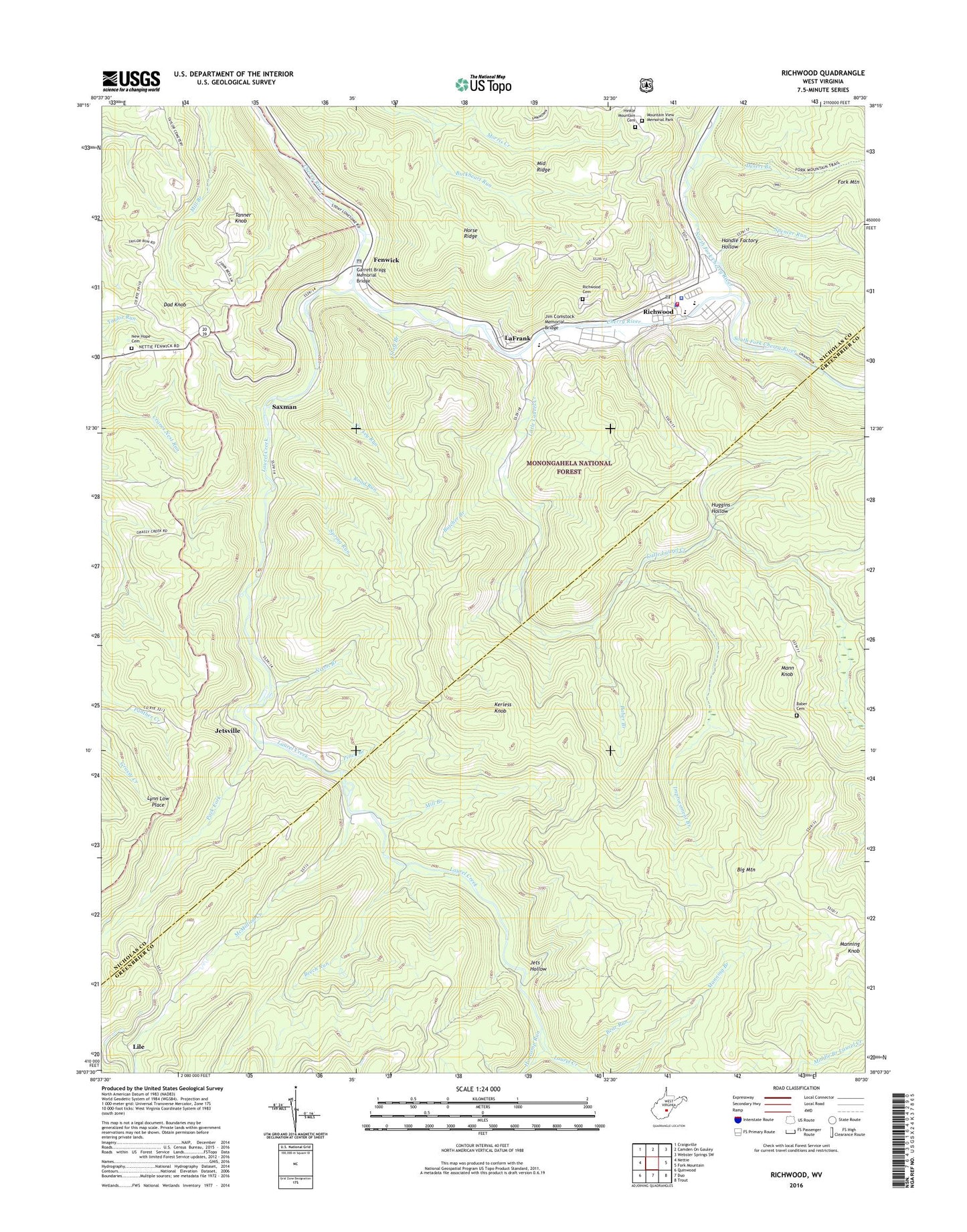
Richwood West Virginia US Topo Map
Couldn't load pickup availability
Also explore the Richwood Forest Service Topo of this same quad for updated USFS data
2023 topographic map quadrangle Richwood in the state of West Virginia. Scale: 1:24000. Based on the newly updated USGS 7.5' US Topo map series, this map is in the following counties: Nicholas, Greenbrier. The map contains contour data, water features, and other items you are used to seeing on USGS maps, but also has updated roads and other features. This is the next generation of topographic maps. Printed on high-quality waterproof paper with UV fade-resistant inks.
Quads adjacent to this one:
West: Nettie
Northwest: Craigsville
North: Camden On Gauley
Northeast: Webster Springs SW
East: Fork Mountain
Southeast: Trout
South: Duo
Southwest: Quinwood
This map covers the same area as the classic USGS quad with code o38080b5.
Contains the following named places: Baber Branch, Baber Cemetery, Bear Run, Beech Run, Big Mountain, Buckheart Run, Butcher Branch, Cherry River Elementary School, Church of God, City of Richwood, Dad Knob, Desert Branch, Fallbrook School, Fenwick, Fenwick Census Designated Place, Fenwick Post Office, First Baptist Church of Richwood, First Church of God, First United Methodist Church, Fork Mountain School, Garrett Bragg Memorial Bridge, Gauley Ranger Station, Handle Factory Hollow, Hinkle Mountain Cemetery, Hinkle Mountain United Methodist Church, Hogcamp Run, Holy Family Catholic Church, Horse Ridge, Horse Ridge School, Huggins Hollow, Improvement Branch, Jets Hollow, Jetsville, Jim Comstock Memorial Bridge, Kerless Knob, LaFrank, LaFrank United Methodist Church, Laurel Creek, Lile, Little Laurel Church, Little Laurel Creek, Little Laurel School, Little Mountain School, Lynn Low Place, Macedonia Church, Mann Knob, McMillion Creek, Middle Ridge, Mill Branch, Milltown School, Mount Hope School, Mountain View Memorial Park, Namo Chapel, New Hope Cemetery, New Hope Church, New Hope School, Nixon Branch, Nixon School, North Fork Cherry River, Pack Fork, Piney Branch, Redi Care Incorporated Station 2, Richwood, Richwood Area Community Hospital, Richwood Cemetery, Richwood Christian Church, Richwood High School, Richwood Middle School, Richwood Police Department, Richwood Post Office, Richwood Presbyterian Church, Richwood Public Library, Richwood Volunteer Fire Department, Riverside Baptist Church, Road Run, Saxman, South Fork Cherry River, Spencer Run, Spring Run, Staff Branch, Tanner Knob, Turkey Run, View School, West Virginia State Police Troop 6 - Richwood Detachment, WVAR Radio Tower (Sturgeon Bay), WVAR-AM (Richwood), ZIP Code: 26261