MyTopo
Moultrie Georgia US Topo Map
Couldn't load pickup availability
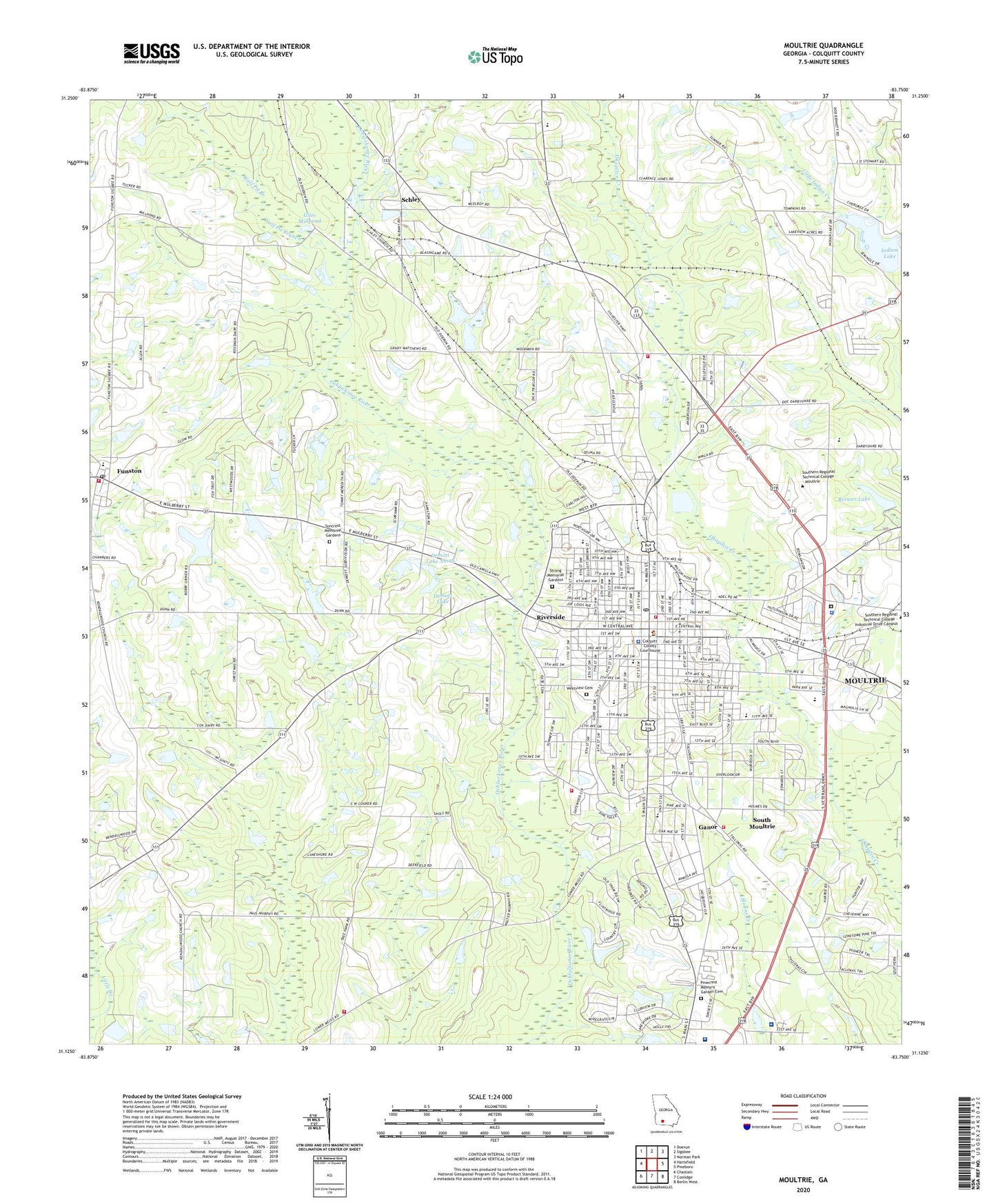
2024 topographic map quadrangle Moultrie in the state of Georgia. Scale: 1:24000. Based on the newly updated USGS 7.5' US Topo map series, this map is in the following counties: Colquitt. The map contains contour data, water features, and other items you are used to seeing on USGS maps, but also has updated roads and other features. This is the next generation of topographic maps. Printed on high-quality waterproof paper with UV fade-resistant inks.
Quads adjacent to this one:
West: Hartsfield
Northwest: Doerun
North: Sigsbee
Northeast: Norman Park
East: Pineboro
Southeast: Berlin West
South: Coolidge
Southwest: Chastain
This map covers the same area as the classic USGS quad with code o31083b7.
Contains the following named places: Assembly of God Tabernacle, Brewer Lake, Brewer Lake Dam, Buckhead School, Calvary Baptist Church, Carnegie Library of Moultrie, Central School, Centreville School, Church of Christ, Church of God, City of Moultrie, Colquitt County, Colquitt County Correctional Institution, Colquitt County Courthouse, Colquitt County Health Center, Colquitt County High School, Colquitt County Jail, Colquitt County Junior High School, Colquitt County Sheriff's Office, Colquitt County Training School, Colquitt County Volunteer Firefighters Association Fire Station 11 Northside, Colquitt County Volunteer Firefighters Association Fire Station 52 Westside, Colquitt County Volunteer Firefighters Association Fire Station 61 Southside, Colquitt County Volunteer Firefighters Association Fire Station 81 Funston, Colquitt Regional Medical Center, Cox School, Crestwood Church, Demott Lake, Demott Lake Dam, Demott Lake North, Demott Lake North Dam, Eastside Baptist Church, First Baptist Church, First Church of the Nazarene, First Methodist Church, First Presbyterian Church, Friendship Baptist Church, Funston, Funston Baptist Church, Funston Baptist Church Cemetery, Funston Elementary School, Funston Methodist Church, Funston Post Office, Ganor, Giles Millpond, Giles Millpond Dam, Grants Chapel African Methodist Episcopal Church, Gray School, Immaculate Conception Catholic Church, Indian Lake, Kendallwood Church, Kirkwood, Marble, Memorial Baptist Church, Memorial Church, Midway Church, Midway Freewill Baptist Church Cemetery, Midway School, Mother Easter Baptist Church, Moultrie, Moultrie Area Technical Institute, Moultrie Arts Center, Moultrie City Hall, Moultrie Division, Moultrie Fire Department Station 1, Moultrie Fire Department Station 2, Moultrie High School, Moultrie Junior High School, Moultrie Plaza Shopping Center, Moultrie Police Department, Moultrie Post Office, Moultrie-Colquitt County Library, New Covenant Church, North End Public School, Northside Church, Oak Grove Baptist Church, Ocklocknee Church, Okapilco School, Pinecrest Memory Garden Cemetery, Pineland School, Pleasant Grove AME Church Cemetery, Pleasant Hill Church, Pleasant Hill Primitive Baptist Church, Ridgewood Church, Riverside, Rocky Ford School, Saint Johns Episcopal Church, Schley, Schley Baptist Church Cemetery, Schley Church, South Moultrie, Strong Memorial Gardens, Suncrest Memorial Gardens, Sunset Country Club, Sunset Plaza Shopping Center, The Church of Jesus Christ of Latter Day Saints, The Market Place Shopping Center, Town of Riverside, Trinity Church, Triumph Church, Turning Point Hospital, Tyson Memorial Church, Union Missionary Baptist Church, Unity Baptist Church, Vereen Memorial Hospital, Vereen School, Westview Cemetery, Williams Tabernacle Christian Methodist Episcopal Church, Willow Church, Withers Auditorium, WMGA-AM (Moultrie), WMGA-AM (Riverside), WMTM-FM (Moultrie), Wolf Pit Branch, Wright School, ZIP Code: 31768