MyTopo
Freeport East Illinois US Topo Map
Couldn't load pickup availability
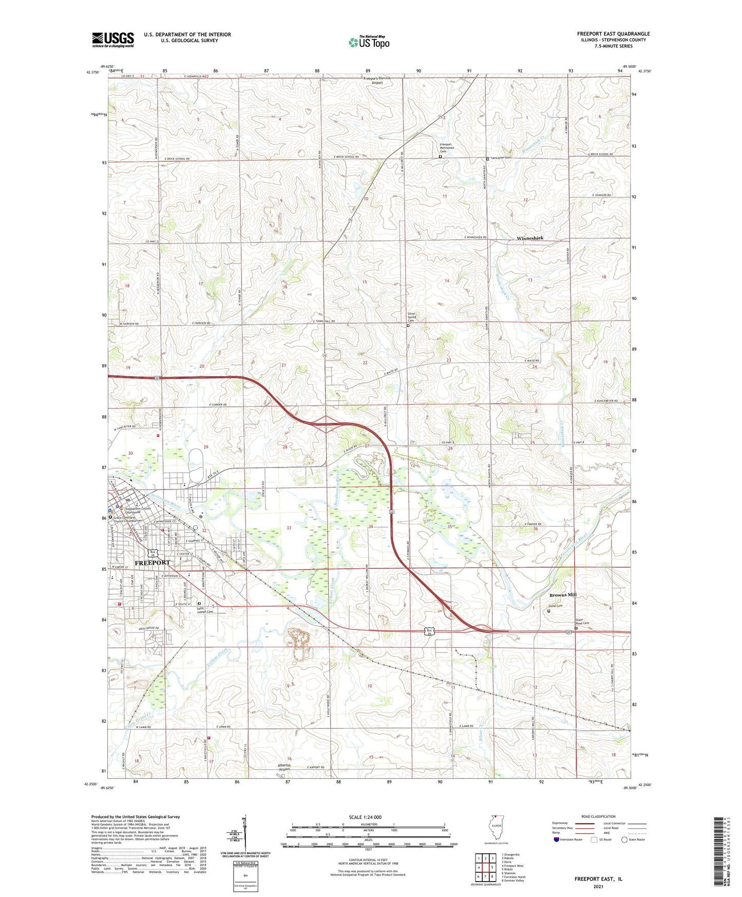
2024 topographic map quadrangle Freeport East in the state of Illinois. Scale: 1:24000. Based on the newly updated USGS 7.5' US Topo map series, this map is in the following counties: Stephenson. The map contains contour data, water features, and other items you are used to seeing on USGS maps, but also has updated roads and other features. This is the next generation of topographic maps. Printed on high-quality waterproof paper with UV fade-resistant inks.
Quads adjacent to this one:
West: Freeport West
Northwest: Orangeville
North: Dakota
Northeast: Davis
East: Ridott
Southeast: German Valley
South: Forreston North
Southwest: Shannon
This map covers the same area as the classic USGS quad with code o42089c5.
Contains the following named places: Aquin High School, Bell School, Bethany United Church of Christ, Bethel Baptist Church, Blackhawk Elementary School, Blanchard School, Browns Mill, Brownsmill Quarry, Center Elementary School, Cherry Hill School, Church of Christ, Church of God in Christ, Crane Grove Creek, Currier School, Dwyer Quarry, Eder School, Elmwood School, Embury United Methodist Church, Evangelical Church of God in Christ, Fairview Quarry, First Church of Christ Scientist, First Church of the Nazarene, First English Evangelical Lutheran Church, First Free Methodist Church, First Presbyterian Church, First United Methodist Church, First Ward Public School, Franzmeir Field, Freeport, Freeport City Hall, Freeport Fire Department Station 2, Freeport Mennonite Cemetery, Freeport Police Department, Freeport Post Office, Freeport Prairie Nature Preserve, Freeport Public Library, Freeport Raceway, Freeport Rural Fire Protection District Station 1, Freeport Rural Fire Protection District Station 2, Freeport/Dornink Airport, Grace Episcopal Church, Graybill Farm, Gund Cemetery, Henney School, Holy Cross Greek Orthodox Church, Immanuel Evangelical Lutheran Church, Immanuel Evangelical Lutheran School, Kingdom Hall, Knollwood Estates Mobile Home Park, Lancaster Cemetery, Lancaster School, Lindo Theatre, Majestic Theater, Mennonite Cemetery, Mennonite Church, Mount Calvary Church of God in Christ, Mount Hope School, Neiman Quarry, Patio Theater, Pleasant Spring School, Pleasant View Church, Pleasant View School, River Road Mobile Home Park, Saint Catherine Catholic Church, Saint Francis School, Saint James Christian Methodist Episcopal Church, Saint Joseph Cemetery, Saint Joseph School, Saint Josephs Home for the Aged, Saint Josephs Roman Catholic Church, Saint Marys Roman Catholic Church, Saint Marys School, Saint Paul Baptist Church, Saint Vincent Childrens Home, Schoonhoven Quarry, Second Baptist Church, Second Presbyterian Church, Silver Creek, Silver Creek School, Silver Spring Cemetery, Silver Spring School, Southside School, State Road Cemetery, State Road Church, State Theater, Stephenson County Courthouse, Stephenson County Fairgrounds, Stephenson County Historical Museum, Stephenson County Jail, Stephenson County Sheriff's Office, Strand Theater, Superba Theater, Taylor Park, Taylor Park Elementary School, Third Ward Park, Township of Lancaster, Tri-County Christian School, Trinity Evangelical United Brethren Church, Valley Creek, WFRL-AM (Freeport), Williams Farm, Winneshiek, WXXQ-FM (Freeport), Yellow Creek, Zion United Church of Christ