MyTopo
Ottumwa North Iowa US Topo Map
Couldn't load pickup availability
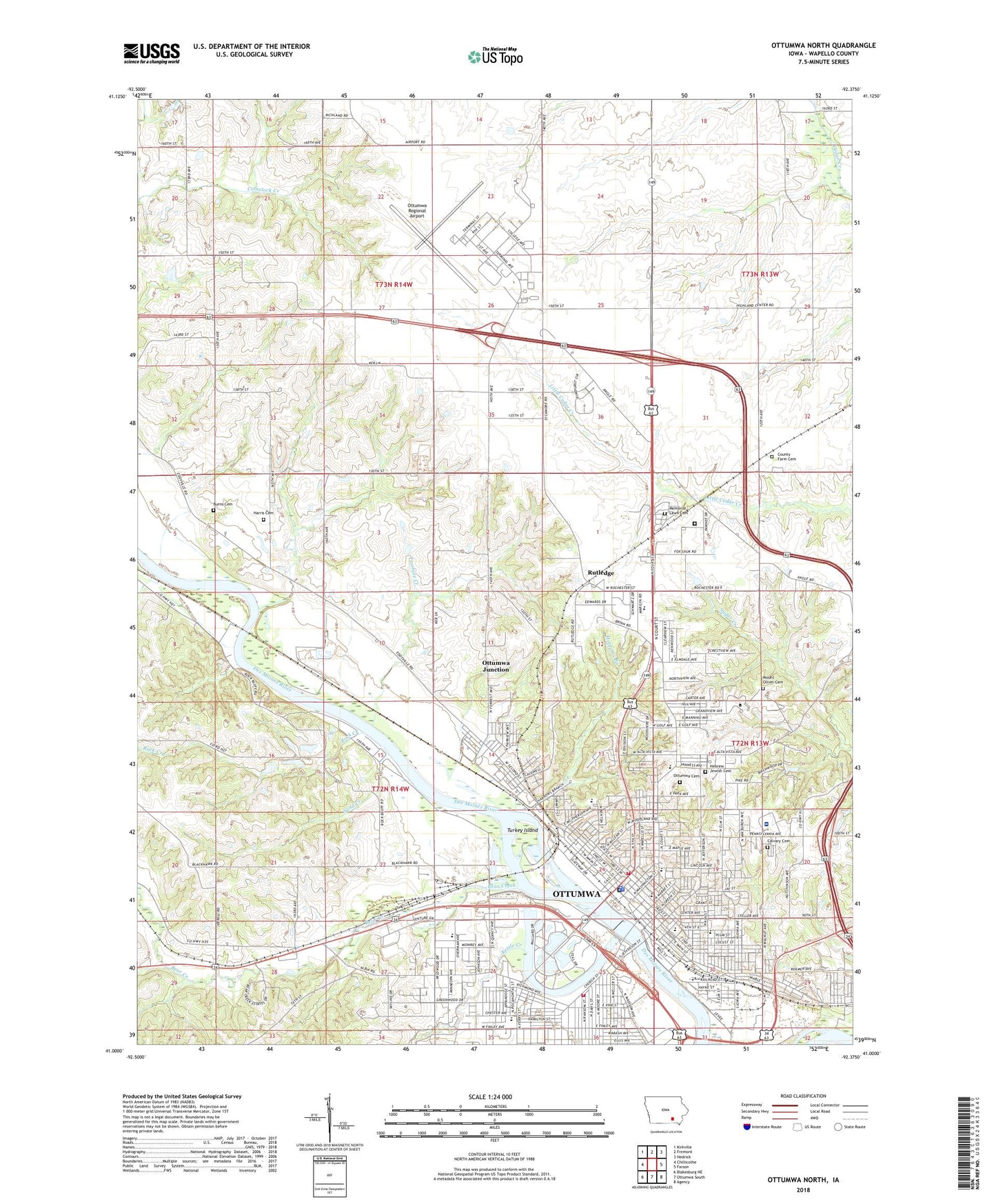
2022 topographic map quadrangle Ottumwa North in the state of Iowa. Scale: 1:24000. Based on the newly updated USGS 7.5' US Topo map series, this map is in the following counties: Wapello. The map contains contour data, water features, and other items you are used to seeing on USGS maps, but also has updated roads and other features. This is the next generation of topographic maps. Printed on high-quality waterproof paper with UV fade-resistant inks.
Quads adjacent to this one:
West: Chillicothe
Northwest: Kirkville
North: Fremont
Northeast: Hedrick
East: Farson
Southeast: Agency
South: Ottumwa South
Southwest: Blakesburg NE
This map covers the same area as the classic USGS quad with code o41092a4.
Contains the following named places: Academic Support Services Building, Administration Building, Advanced Technology Center, Albia Road Podiatry Clinic, Albia Road Southern Baptist Church, Apostolic Church of Christ, Appanoose County Alternative High School, Appanoose Hall, Associates in Dermatology Center, Bear Creek, Bear Creek School, Bearcreek Post Office, Bennett Student Services Center, Bethany Baptist Church, Bethel United Pentecostal Church, Black Hawk River Access, Blackhawk School, Bnai Jacob Synagogue, Burns Cemetery, Caldwell Park, Calvary Baptist Church, Calvary Baptist School, Calvary Cemetery, Calvary Open Bible Church, Camp Wish-Ton-Wish, Central Park, Child Development Center, Child Health Specialty Clinic, Church of God Prophecy, Church of Jesus Christ Ottumwa, City of Ottumwa, Cornerstone Community Church, County Farm Cemetery, Culinary Arts - Hills Diner, Davis Street Christian Church, Department of Corrections - Ottumwa Residential Facility, Ear Nose and Throat Surgical Associates Center, Ear Nose Throat Center of Southeast Iowa, East End Christian Church, East End Pentecostal Church, East End Presbyterian Church, East Ottumwa, Efner Academic Hall, Eisenhower Elementary School, Elm Grove School, Elm Grove School Number 3, Evangelistic Foursquare Church, Evans Middle School, Faith Chapel Open Bible, Family Eye Care Clinic, Family Health Center, Family Practice Center, First Assembly of God Church, First Baptist Church, First Christian Church, First Church - Open Bible, First Church of Christ Science, First Church of God, First Church of the Nazarene, First Church of the Open Bible, First Foursquare Church, First Lutheran Church, First Pentecostal Assembly of God Church, First Presbyterian Church, Foster Park, Franklin School, Godfrey Post Office, Greater Ottumwa Park, Hamilton Park, Harris Cemetery, Harrows Branch, Heartland Eye Care Center, Hedrick School, Hellyer Student Life Center, High Point Foursquare Gospel Church, Hillcrest Park, Horace Mann Elementary School, Indian Hills Community College, Internal Medicine of Ottumwa Center, Iowa Physicians Clinic, Irving School, James Elementary School, Jefferson Street Viaduct, Jehovahs Witnesses, KBIZ-AM (Ottumwa), Keb, Keb Post Office, Keokuk Hall, Kettle Creek, KLEE-AM (Ottumwa), KOTM-FM (Ottumwa), KTWA-FM (Ottumwa), Lang Eye Clinic, Lincoln School, Mahaska Hall, Maintenance Storage and Horticulture Building, Marge Dodd Stage, Memorial Lawn Cemetery, Memorial Park, Menneika Creek, Moore Hearing Clinic, Mount Olivet Cemetery, Naval Air Station Ottumwa, New Hope Baptist Church, New Life Church, North Court Baptist Church, Northgate Alliance Church, Oak Hall, Oak Meadow Obstetrics and Gynecology Center, Orchard School, Ottumwa, Ottumwa Cemetery, Ottumwa Christian School, Ottumwa Church of Christ, Ottumwa City Fire Department Station 1, Ottumwa City Fire Department Station 2, Ottumwa City Hall, Ottumwa Coliseum, Ottumwa Community Church, Ottumwa Country Club, Ottumwa Dermatology Clinic, Ottumwa Family Health Center, Ottumwa Family Practice Center, Ottumwa Foot and Ankle Clinic, Ottumwa Good Samaritan Center, Ottumwa High School, Ottumwa Hospital Heliport, Ottumwa Jewish Cemetery, Ottumwa Junction, Ottumwa Manor, Ottumwa Municipal Golf Course, Ottumwa Obstetrics and Gynecology Center, Ottumwa Park Campground, Ottumwa Pediatrics Center, Ottumwa Police Department, Ottumwa Post Office, Ottumwa Public Library, Ottumwa Regional Airport, Ottumwa Regional Health Center, Ottumwa Regional Health Center Alta Vista Campus, Ottumwa Union Depot, Penn Avenue Free Methodist Church, Phillips, Pickwick, Plymouth Congergational United Church, Port Richmond, Port Richmond Post Office, Railroad Park, Reveal School, Ridgewood Nursing and Rehabilitation Center, Riverside Park, Riverside United Methodist Church, Rock Bluff Park, Rock Creek, Rutledge, Rutledge Post Office, Rutledge School, Sacred Heart School, Saint John Auditorium, Saint Marys Catholic Church, Saint Patricks Catholic Church, Saint Patricks School, Saint Paul Lutheran Church, Sand Creek, Savannah Church of Christ, Schaefer Field, Second Baptist Church, Seton Catholic Elementary School, Seventh Day Adventist Church, Skyline Mobile Park, South Prairie Area School, Spring Creek, Stuart School, Student Lounge, Sunnyside Care Center, The Beach Ottumwa, The Church of Jesus Christ of Latter Day Saints, The Dragroon Trail Historical Marker, Tindell School, Tom Arnold Net Center, Township of Center, Township of Richland, Trinity Church of the Nazarene, Trinity Episcopal Church, Trustee Hall, Turkey Island, Twomile Creek, Union Park, University of Iowa Family Care Center, Video Conferencing and Training Center, Vista Woods Care Center, Walsh High School, Wapello County, Wapello County Courthouse, Wapello County Historical Museum, Wapello County Home, Wapello County Sheriff's Office, Wapello Hall, War Memorial Park, Washington Bicentennial Recognition Historical Marker, Washington Junior High School, Wesley United Methodist Church, Westminster Presbyterian Church, White School, Wildwood Elementary School, Wildwood Evangelical Free Church, Wildwood Park, Williamson Dental Clinic, Wilson Elementary School, ZIP Code: 52501