MyTopo
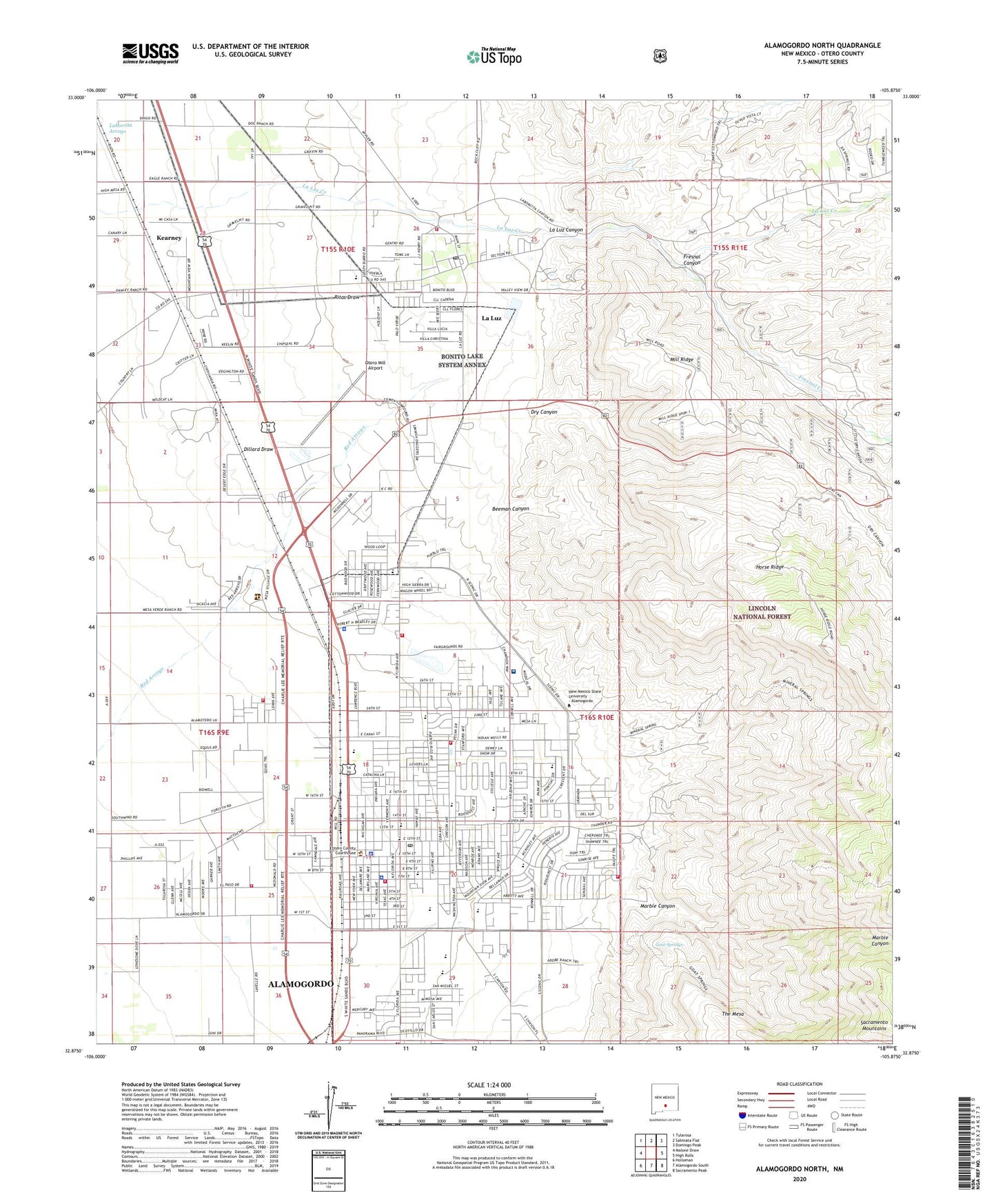
Alamogordo North New Mexico US Topo Map
Couldn't load pickup availability
Also explore the Alamogordo North Forest Service Topo of this same quad for updated USFS data
2023 topographic map quadrangle Alamogordo North in the state of New Mexico. Scale: 1:24000. Based on the newly updated USGS 7.5' US Topo map series, this map is in the following counties: Otero. The map contains contour data, water features, and other items you are used to seeing on USGS maps, but also has updated roads and other features. This is the next generation of topographic maps. Printed on high-quality waterproof paper with UV fade-resistant inks.
Quads adjacent to this one:
West: Malone Draw
Northwest: Tularosa
North: Sabinata Flat
Northeast: Domingo Peak
East: High Rolls
Southeast: Sacramento Peak
South: Alamogordo South
Southwest: Holloman
This map covers the same area as the classic USGS quad with code o32105h8.
Contains the following named places: 10035 Water Well, 10042 Water Well, 88337, Abundant Life Family Church, Agape Christian Center, Alameda Park, Alamo West Fire Rescue Station 1, Alamogordo, Alamogordo Baptist Temple, Alamogordo Christian Academy, Alamogordo Department of Public Safety Station 6, Alamogordo Department of Public Safety Station 7, Alamogordo Fire Department Station 4, Alamogordo Historic Site, Alamogordo Korean Church, Alamogordo Post Office, Alamogordo Water Supply Reservoir Dam, Alamogordo Weather Station, American Medical Response, Ba'hai Church, Beeman Canyon, Berean Independent Baptist Church, Bethel Baptist Church, Bible Missionary Church, Body of Christ Temple, Boles Acres Baptist Church, Buena Vista School, Calvary Baptist Church, Calvary Chapel, Center for Exceptional Children, Central Church of Christ, Centro Evangelistico de Trinidad, Chaparral Junior High School, Christ Community Church, Christadelphian Chapel, Christian Church, Christian Science Church, Church of Christ, Church of God, Church of God Prophecy, Church of Nazarene, City of Alamogordo, Community Christian School, Corinth Baptist Church, Cottonwood Wash, Cuba Avenue Church of Christ, Davis Memorial Church, Deliverance Temple, DH Sutherland House Historic Site, Dog Canyon Historical Marker, Dry Canyon, Dudley School, Dungan Volunteer Fire Department Station 1 Headquarters, Dungan Volunteer Fire Department Station 2, El Divino Salvador Church, Faith Baptist Church, Father James B Hay Catholic School, First Assembly of God Church, First Baptist Church, First Christian Church, First Presbyterian Church, First United Pentecostal Church, Fresnal Canyon, Fresnal Creek, Full Gospel Lighthouse, Gateway Baptist Church, Gerald Champion Memorial Hospital Library, Gerald Champion Regional Medical Center, Goat Springs, Gorby Ranch Airport, Grace Baptist Church, Grace United Methodist Church, Harry Francis Acley House Historic Site, Hay School, Heights School, Holmes Mine, Horse Ridge, Immaculate Conception Catholic Cemetery, Immanuel Baptist Church, Juan Garcia House Historic Site, Juan Jose Gutierrez House Historic Site, KALG Radio Tower, Kearney, KINN-FM (Alamogordo), KPSA-AM (Alamogordo), KPSA-FM (La Luz), KYEE-FM (Alamogordo), KZZX-AM (Alamogordo), La Luz, La Luz Canyon, La Luz Census Designated Place, La Luz Post Office, La Luz Pottery Factory, La Luz Townsite Historic District, La Luz Volunteer Fire Department, Laborcita Arroyo, Light of the Word Church, Light of the World Fellowship Church, Macedonia Church of God, Marble Canyon, Mill Ridge, Mission Gethsemane, Monastery of Saint Anthony, Monte Vista Cemetery, Montessori Learning School, Mountain View Assembly of God Church, Mountain View Baptist Church, New Hope Baptist Church, New Mexico Museum of Space History, New Mexico School for the Visually Handicapped, New Mexico State Police District 8 Alamogordo, New Mexico State University (Alamogordo Branch), New Zion Baptist Church, North School, Oregon School, Ortega Pit, Otero County Sheriff's Office, Otero Mill Airport, Our Saviour Lutheran Church, Outreach Gospel Ministries Church, Owens Chapel AME, Parabolic Dune Hearth Mounds, Peace Tabernacle, Primera Iglesia Bautista, Queen Ann House, Reorganized Church of Latter Day Saints, Sacramento School, Saint Anthony the Great Monastery, Saint Johns Episcopal Church, Saint Jude Mission, Salado Canyon, Seventh Day Adventist Church, Sierra School, Six Jornada Mogollon Villages in Alamogordo, Southwestern Bible Tabernacle, Space Center Teacher-Student Resource Center, Spanish Baptist Church, State School for Blind, Temple Calvario Asambleas de Dios, Templo Ebe-Nezer Church, The Body of Christ Temple, The Church of Christ, The Church of Jesus Christ of Latter Day Saints, The Door Christian Fellowship Church, The Potters House, The Space Center, Tiger Field, Trinity Lutheran Church, Tularosa Basin Historical Society, Unitarian Fellowship Church, Unitarian Universalist Church, Wesley United Methodist Church, Westminster Reformed Church, White Dove of the Desert Cemetery, White Sands National Monument Historic District, Yucca School, Zia School