MyTopo
Bellefonte Pennsylvania US Topo Map
Couldn't load pickup availability
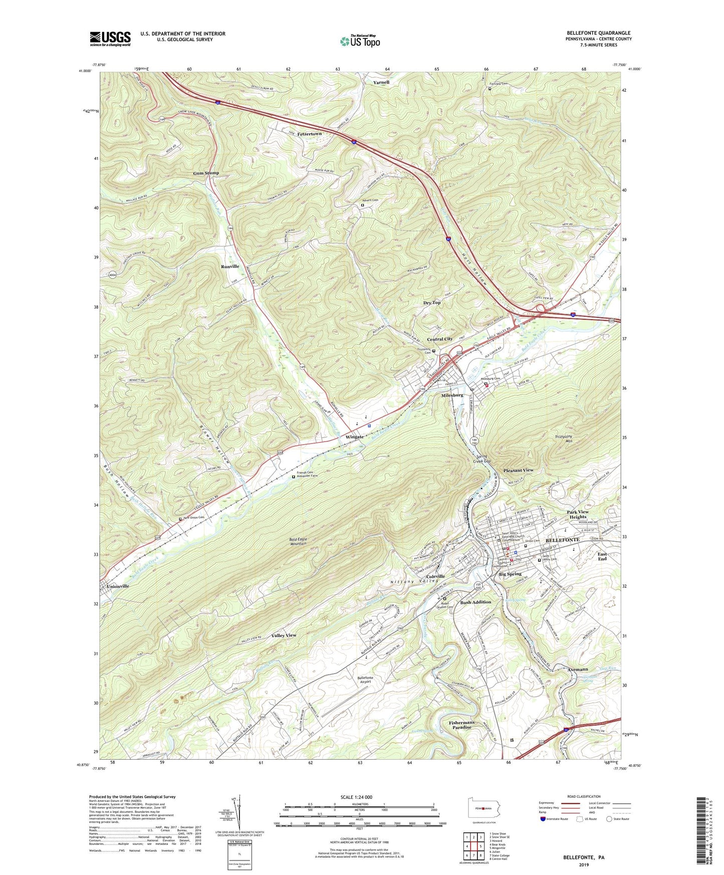
2023 topographic map quadrangle Bellefonte in the state of Pennsylvania. Scale: 1:24000. Based on the newly updated USGS 7.5' US Topo map series, this map is in the following counties: Centre. The map contains contour data, water features, and other items you are used to seeing on USGS maps, but also has updated roads and other features. This is the next generation of topographic maps. Printed on high-quality waterproof paper with UV fade-resistant inks.
Quads adjacent to this one:
West: Bear Knob
Northwest: Snow Shoe
North: Snow Shoe SE
Northeast: Howard
East: Mingoville
Southeast: Centre Hall
South: State College
Southwest: Julian
This map covers the same area as the classic USGS quad with code o40077h7.
Contains the following named places: Advent Cemetery, Advent Church, Axemann, Axemann Spring, Bald Eagle Area Middle - Senior High School, Bald Eagle Mine Station, Bellefonte, Bellefonte Airport, Bellefonte Emergency Medical Services Company 26, Bellefonte Police Department, Bellefonte Post Office, Bellefonte Station, Big Spring, Bishop Street School, Borough of Bellefonte, Borough of Milesburg, Brower Hollow, Brower Hollow Run, Buffalo Run, Buffalo Run Church, Bush Addition, Bush Hollow, Bush Hollow Run, Central City, Centre County, Centre County Sheriff's Office, Chemical Station, Citizen's Fire Company 9, Coleville, Commonwealth of Pennsylvania, Dewitt Run, Dry Top, East End, Fairview Cemetery, Fairview Church, Fetzertown, Fishermans Paradise, Forge Union Church, Forked Spring, Friends Cemetery - Alexander Farm, Gum Stump, Holt Hollow, Holt Run, Kelley Spring, Knox School, Logan Branch, Logan Fire Company 1, Milesburg, Milesburg Cemetery, Milesburg Post Office, Moose Run, Moose Run Census Designated Place, Morris, New Bush Hollow Church, New Union Cemetery, Park View Heights, Pennsylvania State Police Troop G Rockview Station, Pleasant View, Rodef Shalom Cemetery, Runville, Runville Census Designated Place, Runville Post Office, Saint Johns Cemetery, Saint John's Episcopal Church Columbarium, Saint Johns School, Spring Creek, Spring Creek Gap, State Game Lands Number 92, Stevens, Township of Boggs, Trcziyulny Cemetery, Trcziyulny Mountain, Undine Fire Company 2, Union Cemetery, Valley View, Wallace Run, WBLF-AM (Bellefonte), Wingate, Yarnell, ZIP Codes: 16823, 16853