MyTopo
Bloomington Indiana US Topo Map
Couldn't load pickup availability
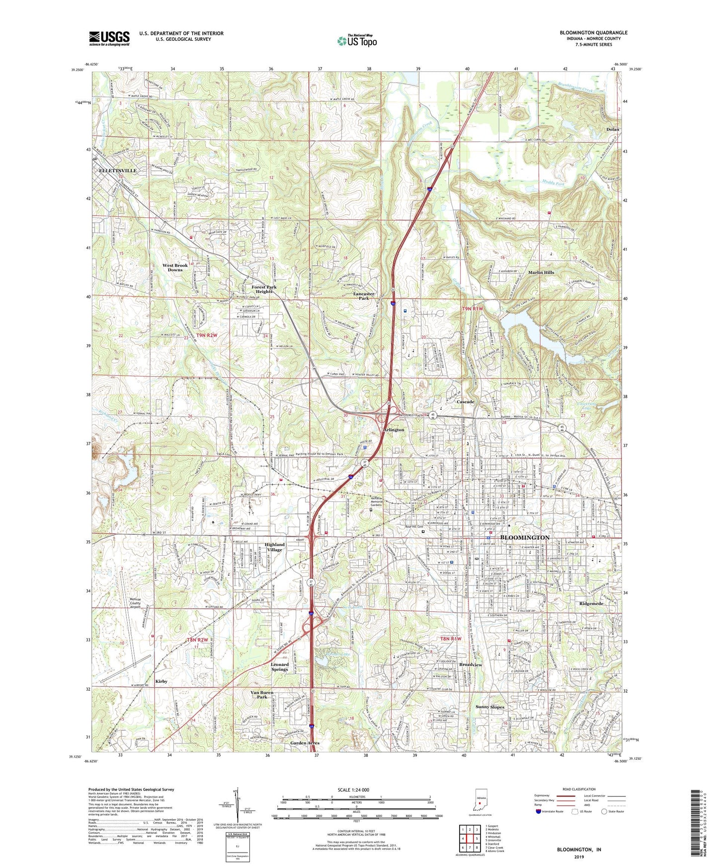
2022 topographic map quadrangle Bloomington in the state of Indiana. Scale: 1:24000. Based on the newly updated USGS 7.5' US Topo map series, this map is in the following counties: Monroe. The map contains contour data, water features, and other items you are used to seeing on USGS maps, but also has updated roads and other features. This is the next generation of topographic maps. Printed on high-quality waterproof paper with UV fade-resistant inks.
Quads adjacent to this one:
West: Whitehall
Northwest: Gosport
North: Modesto
Northeast: Hindustan
East: Unionville
Southeast: Allens Creek
South: Clear Creek
Southwest: Stanford
This map covers the same area as the classic USGS quad with code o39086b5.
Contains the following named places: Arlington, Arlington Heights Elementary School, Bethel Church, Binford Middle School, Bloomington, Bloomington Fire Department Station 1, Bloomington Fire Department Station 1 Headquarters, Bloomington Fire Department Station 2, Bloomington Fire Department Station 3, Bloomington Fire Department Station 4, Bloomington Fire Department Station 5, Bloomington Meadows Hospital, Bloomington Police Department, Bloomington Post Office, Bloomington Quarry, Bloomington South High School, Bloomington Township Fire Department Station 15, Bloomington Township Fire Department Station 5, Broadview, Bryan Park, Camp Wapehani, Cascade, Cascade Park, Central Junior High School, City of Bloomington, Crossroads Church, Dyer Middle School, Ellettsville Fire Department Station, Ellettsville Fire Department Station 8, Ellettsville Post Office, Elm Heights School, Fairview Elementary School, Faith Church, Forest Park Heights, Grandview Elementary School, Griffy Creek, Griffy Reservoir, Gritty Reservoir Dam, Headley School, Hensonburg School, Highland Village, Hunter School, Hunter Switch, Hunter Valley Quarry, Indiana State Police Department Bloomington District 33, Indiana University, Indiana University Police Department, Indiana University Stadium, IU Health Bloomington Hospital, Kirby, Lancaster Park, Leonard Springs, Maple Grove Christian Church, Maple Hill Quarry, Marlin Elementary School, Marlin Hills, McCalla School, Meadows Hospital, Monroe County, Monroe County Airport, Monroe County Auxiliary Police Department, Monroe County Sheriff's Office, Morey Lake Dam, Muddy Fork, New Prospect Church, Northern Monroe Fire Territory Station 5, Ridgemede, Rogers Elementary School, Rose Hill Cemetery, Saint Charles Boromeo School, Saint Pauls Church, Stewart Tabernacle, Stout Creek, Sunny Slopes, Templeton Elementary School, Town of Ellettsville, Township of Bloomington, Twin Lakes, University Elementary School, University Lake, University Lake Dam, University Middle School, Valhalla Memorial Gardens, Van Buren Park, Van Buren Township Fire Department, Weimer Lake, Weimer Lake Dam, West Brook Downs, Woolery Stone Quarry, ZIP Codes: 47404, 47405, 47406